Essential Tools for Conjunctive Use Projects
Groundwater models save time and money while streamline permitting processes for conjunctive use projects
Groundwater models save time and money while streamline permitting processes for conjunctive use projects
Weather extremes and growing populations are driving water agency leaders and municipalities to new resources and methods to procure reliable, affordable water supplies.
Conjunctive use projects proliferate across the Southwest as stressed water systems attempt to extend water supplies, accelerate wastewater recycling, mitigate groundwater aquifer overdrafts, and reduce long-term water production costs.
These projects are complex, expensive, and potentially risky with millions of tax and rate payer funds and usable water supplies in jeopardy. This is why conjunctive use projects need to start with a comprehensive, up-to-date, calibrated groundwater model – the only tool that effectively mitigates these risks.
Conjunctive use projects involve the coordinated use of surface water and groundwater. Traditionally, these water sources were managed separately, but with demand outpacing supply, more water managers are considering conjunctive use projects to ensure adequate water supplies. Conjunctive use projects maximize water resources with both active and passive capture, storage, and recharge methods.
Essential Resources
Groundwater models are essential, not optional, tools for every phase of conjunctive use projects. Model type and provider are equally vital. The hydrogeologic conceptual model and groundwater flow and/or solute transport models need to be accurate, calibrated, and appropriate for the specific basin and project requirements.
Learn more about choosing the right model and consulting firm in our Groundwater Modeling 101 series.
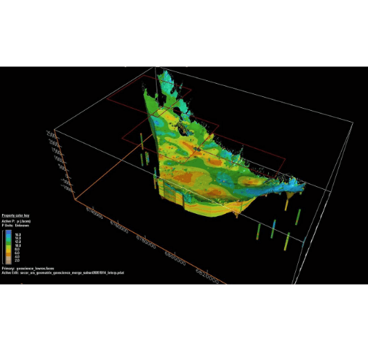
A calibrated groundwater model (representing a digital twin of a complex groundwater basin), delivered by an experienced, validated firm, can inform every stage of a conjunctive use project including:
- Planning
- Design and permitting
- Construction
- Operations, management, and future development
Creating detailed groundwater models to accurately assess supply, storage, and production for potential projects requires sufficient hydrogeologic understanding of the project area and proficient application of modeling software for groundwater and/or surface water flow systems.
Without this invaluable resource, the conjunctive use project may fail to produce adequate water supplies or effectively recharge groundwater and may even result in contaminated drinking water production wells.
In addition to informed conjunctive use project planning, water managers can use a well-developed and calibrated groundwater model as a multi-use tool to facilitate regulatory compliance with the Sustainable Groundwater Management Act (SGMA), Drinking-Water Source Assessment and Protection (DWSAP) program, and more.
Effective, Efficient Groundwater Project Planning
A new, or updated, calibrated groundwater model saves money up front by eliminating the need to drill extensive, experimental test wells. Instead, hydrogeologic model development uses existing information to create detailed mathematical models with integrated data from topography, historical water runoff and accumulation, groundwater wells and pumping, measured groundwater elevations and water quality, faults, and other manmade and natural features affecting groundwater flow.
Results from the groundwater model allow us to design targeted field investigations, saving considerable time, money, and project resources typically spent installing numerous, expensive, speculative test wells.
The field investigation data confirms, or is used to refine, the groundwater model delivering improved resolution and providing confidence in project simulations.
Groundwater basin and hydrology modeling can save 75% of the project planning budget by enabling precision field investigations to confirm model data or fill knowledge gaps versus field testing with speculative well drilling alone.
The resulting interactive, three-dimensional model, or groundwater basin digital twin, informs strategic project planning, facilitates extrapolation based on future conditions, and supports permit applications to accelerate approvals.
Groundwater Modeling and Informed Conjunctive Use Planning in Action
The City of Oceanside relied on imported water for more than 85% of its supply. Less than 15% of water delivered to customers came from local supplies in the Mission Groundwater Basin or the city’s recycled water facility.
A conjunctive use project presented the best way to reduce reliance on imported water and create a sustainable local supply in the Mission Basin, which was over drafted.
Geoscience conducted a phased evaluation characterizing the Mission Basin, developed a groundwater model, and studied groundwater storage and recovery project feasibility in the Lower San Luis Rey River Valley.
Additionally, the project encompassed:
- Assessing groundwater replenishment reuse projects using treated wastewater from the San Luis Rey Water Reclamation Facility that would otherwise be discharged to the ocean
- Groundwater analyses, using the Mission Basin Groundwater Model to evaluate the conjunctive use project’s impact on groundwater quality and quantities
- Assessing technical and regulatory issues, identifying advanced wastewater treatment methods, and developing groundwater recharge options
Results
The modeling and investigation verified the potential for successful Mission Basin conjunctive-use storage projects and determined that up to ~5,000 AFY of recycled water could be recharged into the basin.
One thousand or 1,000 AFY (acre-feet per year) is the equivalent of 0.8921 million gallons per day (892,100 gallons per day).
The updated Mission Basin Groundwater Model and associated findings empowered the City of Oceanside to move forward with their indirect potable reuse (IPR) groundwater augmentation project, called Pure Water Oceanside, expanding the City’s existing Title 22 tertiary recycled water distribution system. The project included building an advanced water purification facility providing the capacity to inject three-million gallons per day (MGD) of treated wastewater into the Mission Basin.
All project work, including pipeline placement and injection and monitoring well permitting and construction, was informed by Geoscience’s groundwater model and the geotechnical studies.
The end result was a local, drought-proof water supply that reduced the city’s reliance on highly variable and expensive imported water. Also, the project increased water supply sustainability and groundwater resources by recharging the Mission Basin with 3,360 AFY of high-quality water, improving the aquifer’s overall water quality and relieving over-pumping conditions.
Beyond Planning
Groundwater modeling’s utility doesn’t end with conjunctive use project planning and permitting. These detailed, interactive water project resources support construction, basin management, ongoing decision making, and future water management strategies.
Groundwater models save time, money, and project resources, while reducing regulatory compliance risks and expensive project missteps.
Geoscience pioneered the groundwater modeling industry with the first computer-aided hydrogeologic model more than 40 years ago, and we continue advancing our capabilities and industry-leading modeling software to provide clients with accurate, reliable, legally defendable groundwater models for informed water project planning and decision making.
Geoscience Models Deliver Successful Groundwater Projects
A collaborative team of engineers, geologists, hydrologists, and modelers, Geoscience focuses on delivering innovative solutions for clients’ groundwater needs – delivering efficient, effective groundwater management and production for nearly five decades.
We empower clients with comprehensive consulting, flow and solute transport modeling, design and construction oversight for high-capacity municipal wells, and groundwater basin management to ensure safe, long-term groundwater supply.
Visit our Groundwater Basin Modeling page to learn more about our hydrogeologic modeling services and how Geoscience helps water agencies and municipalities plan and execute conjunctive use projects. And get in touch to find out how we can save you time and money with a comprehensive groundwater basin model.
Discover more news
Groundwater Models 101: Choosing the Right Modeling Firm
Essential insights for water utility leaders to understand modeling's critical role in decision making and groundwater project success
Read moreGroundwater Models 101: The Right Model for Your Needs
A guide to choosing the right groundwater model to support critical decision making and promote project success
Read moreGroundwater Models 101: The Necessity of Calibration
Why and how to calibrate a groundwater model, and why it’s critical to model functionality and project success
Read more